West Bengal

West Bengal
West Bengal is a state in the eastern region of India along the Bay of Bengal. With over 91 million inhabitants, it is the fourth-most populous state and the thirteenth-largest state by area in India. Covering an area of 88,752 km2 (34,267 sq mi), it is also the world's seventh-most populous country subdivision. Part of the Bengal region of the Indian subcontinent, it borders Bangladesh in the east, and Nepal and Bhutan in the north. It also borders the Indian states of Odisha, Jharkhand, Bihar, Sikkim and Assam. The state capital is Kolkata, the seventh-largest city, and the third-largest metropolitan area in India. West Bengal includes the Darjeeling Himalayan hill region, the Ganges delta, the Rarh region and the coastal Sundarbans. The state's main ethnic group are the Bengalis, with the Bengali Hindus forming the demographic majority.
The area's early history featured a succession of Indian empires, internal squabbling, and a tussle between Hinduism and Buddhism for dominance. Ancient Bengal was the site of several major Janapadas, while the earliest cities date back to the Vedic period. The region was part of several ancient pan−Indian empires, including the Mauryans, and the Guptas. The citadel of Gauḍa served as the capital of the Gauḍa Kingdom, the Pala Empire, and the Sena Empire. Islam was introduced through trade with the Abbasid Caliphate, but following the early conquest of Bakhtiyar Khalji and the establishment of the Delhi Sultanate, the faith spread across the entire Bengal region. During the Bengal Sultanate, Bengal was a major trading nation in the world, and was often referred by the Europeans as the "richest country to trade with". It was absorbed into the Mughal Empire in 1576. Simultaneously, some parts of the region were ruled by several Hindu states, and Baro-Bhuyan landlords, and part of it was briefly overrun by the Suri Empire. Following the death of Emperor Aurangzeb in the early 1700s, the proto-industrialised Mughal Bengal became a semi-independent state under the Nawabs of Bengal. The region was later conquered by the British East India Company at the Battle of Plassey in 1757.
The region was a hotbed of the Indian independence movement and has remained one of India's great artistic and intellectual centres. Following widespread religious conflict, the Bengal Legislative Council and the Bengal Legislative Assembly voted on the Partition of Bengal in 1947 along religious lines into two independent dominions: West Bengal, a Hindu-majority Indian state, and East Bengal, a Muslim-majority province of Pakistan which later became the independent Bangladesh.
Post independence, West Bengal's economy is based on agricultural production and small and medium-sized enterprises. For many decades the state underwent political violence and economic stagnation. Today, the economy of West Bengal is the sixth-largest state economy in India with a gross state domestic product (GSDP) of ₹11.77 lakh crore (US$170 billion), and has the country's 23rd-highest GSDP per capita of ₹109,000 (US$1,500). West Bengal also has the 28th-highest ranking among Indian states in human development index. The state government debt of ₹4.0 lakh crore (US$56 billion), or 32.6% of GSDP, is fifth highest India, but has dropped from 40.65% since 2010–11. There is moderate unemployment. West Bengal has two World Heritage sites and ranks seventh-most visited tourist destination in India.
History
The name of Bengal, or Bangla, is derived from the ancient kingdom of Vanga, or Banga. References to it occur in early Sanskrit literature, but its early history is obscure until the 3rd century BCE, when it formed part of the extensive Mauryan empire inherited by the emperor Ashoka. With the decline of Mauryan power, anarchy once more supervened. In the 4th century CE the region was absorbed into the Gupta empire of Samudra Gupta. Later it came under control of the Pala dynasty. From the beginning of the 13th century to the mid-18th century, when the British gained ascendancy, Bengal was under Muslim rule—at times under governors acknowledging the suzerainty of the Delhi sultanate but mainly under independent rulers.
In 1757 British forces under Robert Clive defeated those of the nawab (ruler) of Bengal, Sirāj al-Dawlah, in the Battle of Plassey near present-day Palashi. In 1765 the nominal Mughal emperor of northern India, Shah ʿĀlam II, granted to the British East India Company the dīwānī of Bengal, Bihar, and Orissa (now Odisha)—that is, the right to collect and administer the revenues of those areas. By the Regulating Act of 1773, Warren Hastings became the first British governor-general of Bengal. The British-controlled government, centred at Calcutta (now Kolkata), was declared to be supreme: essentially, the governor-general of Bengal was the chief executive of British India. Thus, the Bengal Presidency, as the province was known, had powers of superintendence over the other British presidencies, those of Madras (now Chennai) and Bombay (now Mumbai).
 |
victoria memorial
 |
Britain was not, however, the only European presence in Bengal. The town of Hugli, north of Calcutta, was the location of a Portuguese factory (trading post) until 1632; Hugli-Chinsura (Chunchura), the next town south, was the Dutch post until 1825; the next town, Shrirampur (Serampore), was the Danish post until 1845; and Chandernagore (Chandannagar) remained in French hands until 1949.
From 1834 Bengal’s governor-general bore the title “governor-general of India,” but in 1854 the post was relieved of the direct administration of Bengal, which was placed under a lieutenant governor. Thenceforward, the government of British India became distinct from that of Bengal. In 1874 Assam was transferred from the charge of the lieutenant governor and placed under a separate chief commissioner. In 1905 the British determined that Bengal had become too unwieldy a charge for a single administration, and, in spite of violent Hindu protests, it was partitioned into two provinces, each under its own lieutenant governor: one comprised western Bengal, Bihar, and Orissa; the other included eastern Bengal and Assam. In 1911, because of continued opposition to partition, Bengal was reunited under one governor, Bihar and Orissa under a lieutenant governor, and Assam once more under a chief commissioner. At the same time, Delhi became the capital of India in place of Calcutta.
 |
| Howrah Bridge |
Under the Government of India Act (1935), Bengal was constituted an autonomous province in 1937. That remained the situation until the Indian subcontinent was partitioned into the two dominions of Pakistan and India after the British withdrawal in 1947. The eastern sector of Bengal, largely Muslim, became East Pakistan (later Bangladesh); the western sector became India’s West Bengal state. The partition of Bengal left West Bengal with ill-defined boundaries and a constant inflow of non-Muslim, mostly Hindu, refugees from East Pakistan. More than seven million refugees entered the already densely populated state after 1947, and their rehabilitation placed an immense burden on the administration.
In 1950 the princely state of Cooch Behar (Koch Bihar) was integrated with West Bengal. After the linguistic and political reorganization of Indian states in 1956, West Bengal gained some 3,140 square miles (8,130 square km) from Bihar. The additional territory provided a link between the previously separated northern and southern parts of the state.
 |
| Cooch Behar Palace |
Land
Relief and drainage
West Bengal may be broadly divided into two natural geographic divisions—the Gangetic Plain in the south and the sub-Himalayan and Himalayan area in the north. The Gangetic Plain contains fertile alluvial soil deposited by the Ganges (Ganga) River and its tributaries and distributaries. It also features numerous marshes and shallow lakes formed out of dead river courses. Indeed, the Ganges, which now runs through the narrow middle section of the state before entering Bangladesh, has been moving steadily eastward for centuries; only a small amount of its water now goes to the sea via the western distributaries, of which the principal one is the Hugli (Hooghly). The state capital, Kolkata, is situated on the Hugli in the southern portion of West Bengal. Another important river, the Damodar, joins the Hugli southwest of Kolkata. The elevation of the plain increases slowly toward the west; the rise is most marked near the Chota Nagpur plateau of neighbouring Jharkhand.
 |
| Chhota nagpur plateau |
The sub-Himalayan tract, known as the West Bengal Duars, or Western Duars, is a part of the Tarai lowland belt between the Himalayas and the plain. Once infested with malaria, the area is now well drained and cultivated. Some of the finest tea plantations of India are situated there. North of the Duars, the Himalayan mountain ranges rise abruptly along the northern boundary of the state. Mount Kanchenjunga, actually located in adjacent Sikkim, dominates the landscape of the area, particularly in Darjiling (Darjeeling). On a clear day, Mount Everest also can be seen in the distance.
 |
| Darjiling |
Climate
West Bengal’s climate is transitional between tropical wet-dry in the southern portions and humid subtropical in the north. Throughout West Bengal there is a pronounced seasonal disparity in rainfall. For example, Kolkata averages about 64 inches (1,625 mm) per year, of which an average of 13 inches (330 mm) falls in August and less than 1 inch (25 mm) in December. The state also is subject to considerable variability from year to year. In the sub-Himalayan region, rainfall is considerably greater. The year may be broadly divided into three marked seasons—the hot and dry season (March to early June), with dry sultry days and frequent thunderstorms; the hot and wet season (mid-June to September), when rain-bearing monsoon winds blow from the southwest; and the cold (cool) season (October to February), when days are dry and clear and stable atmospheric conditions prevail. Average high temperatures at Kolkata range from about 80 °F (27 °C) in December and January to nearly 100 °F (38 °C) in April and May.
Plant and animal life
Forests occupy more than one-tenth of the total land area of the state, and the region as a whole has a rich and varied plant life. In the sub-Himalayan plains the principal forest trees include sal (Shorea robusta) and shisham, or Indian rosewood (Dalbergia sissoo); the forests are interspersed with reeds and tall grasses. On the Himalayan heights vegetation varies according to the elevation, with coniferous belts occurring at higher levels. The delta of the Hugli constitutes the western end of the dense coastal mangrove forest called the Sundarbans. A large portion of that unreclaimed and sparsely populated area bordering Bangladesh and the Bay of Bengal has been set aside as a national park and also (along with the portion in Bangladesh) as a UNESCO World Heritage site (designated 1987).
 |
| Sundarban national park |
The forests are inhabited by tigers, leopards, elephants, gaurs (wild cattle), and rhinoceroses, as well as by other animals of the Indian plain, large and small. Reptiles and birds include the same species as are common throughout the Indian subcontinent. In addition to the Sundarbans park, the state has several other protected natural areas, including Jaldapara Wildlife Sanctuary and a tiger reserve.
 |
| Jaldapara national park |
Economy
Agriculture
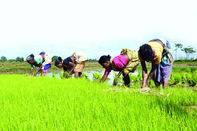
Agriculture dominates both the landscape and the economy of West Bengal. Its proportion of agricultural land is among the highest of all the Indian states. Rice, which requires extensive irrigation, is the leading crop in nearly every area. Indeed, despite its relatively small size, West Bengal produces a significant percentage of India’s rice harvest. Other major crops are sugarcane and oilseeds. Jute is especially prominent along the border with Bangladesh and south of the Ganges River. Mangoes, jackfruit, and bananas are widely produced in the southern and central portions of the state. Wheat and potatoes are produced as winter crops throughout the south. The northern areas around Darjiling and Jalpaiguri have long been known for their production of high-quality tea. The Darjiling region also produces oranges, apples, pineapples, ginger, and cardamom.
 |
| Agriculture zone in west bengal |
Industry
The state’s most important industrial belt is a corridor extending for a distance north and south of Kolkata, along the Hugli River. Another significant industrial region is located along the Damodar River. There are steel plants at Durgapur and Burnpur and a locomotive plant at Chittaranjan. Haldia, the terminus of an oil pipeline from Assam and the site of a large oil refinery, also has a petrochemical industry. Other important manufactures include ships, automobiles, chemicals and fertilizers, wagons, electronics, paper, jute, and cotton textiles. The state has a large number of small-scale and cottage industries as well. In the late 20th and early 21st centuries, the only mineral resources of West Bengal that sustained nationally significant exploitation were coal and clay for brickmaking.
Services
The service sector has accounted for an increasing proportion of the state’s economy. Trade, finance, insurance, and related activities have grown significantly, and tourism has become increasingly important. Also experiencing growth has been the information technology sector. Kolkata is the financial centre for both the state and eastern India.
Education
 |
| Shantiniketan |
West Bengal has more than 10 degree-granting universities, as well as engineering and medical colleges and many technical institutes. The University of Calcutta (1857) and Jadavpur (1955) and Rabindra Bharati (1962) universities are all located in Kolkata. The science laboratories of the University of Calcutta, the Indian Association for the Cultivation of Science, and the Bose Institute have made notable contributions to science. The Asiatic Society of Bengal, a scholarly organization founded in 1784, is headquartered in Kolkata. Vishva-Bharati University, in Shantiniketan (now part of Bolpur), is a world-famous centre for the study of Indology and international cultural relations.
 |
Rabindra bharti university
|
The state has a central library, together with a number of district, area, and rural libraries. More than 5,000 adult education centres aid in literacy training. The state’s literacy rate, which exceeded 75 percent in the early 21st century, is one of the highest in India, and the disparity in the rate between men and women is lower than the national average.
| District | Population | Growth rate | Sex ratio | Literacy | Density per square Kilometer |
|---|
| North 24 Parganas | 10,009,781 | 12.04 | 955 | 84.06 | 2445 |
| South 24 Parganas | 8,161,961 | 18.17 | 956 | 77.51 | 819 |
| Purba Bardhaman | 4,835,432 | – | 945 | 74.73 | 890 |
| Paschim Bardhaman | 2,882,031 | – | 922 | 78.75 | 1800 |
| Murshidabad | 7,103,807 | 21.09 | 958 | 66.59 | 1334 |
| West Midnapore | 5,913,457 | 13.86 | 966 | 78.00 | 631 |
| Hooghly | 5,519,145 | 9.46 | 961 | 81.80 | 1753 |
| Nadia | 5,167,600 | 12.22 | 947 | 74.97 | 1316 |
| East Midnapore | 5,095,875 | 15.36 | 938 | 87.02 | 1081 |
| Howrah | 4,850,029 | 13.50 | 939 | 83.31 | 3306 |
| Kolkata | 4,496,69 | −1.67 | 908 | 86.31 | 24306 |
| Maldah | 3,988,845 | 21.22 | 944 | 61.73 | 1069 |
| Jalpaiguri | 3,872,846 | 13.87 | 953 | 73.25 | 622 |
| Alipurduar | 1,700,000 | – | – | – | 400 |
| Bankura | 3,596,292 | 12.64 | 954 | 70.95 | 523 |
| Birbhum | 3,502,404 | 16.15 | 956 | 70.68 | 771 |
| North Dinajpur | 3,007,134 | 23.15 | 939 | 59.07 | 958 |
| Purulia | 2,930,115 | 15.52 | 957 | 64.48 | 468 |
| Cooch Behar | 2,819,086 | 13.71 | 942 | 74.78 | 832 |
| Darjeeling | 1,846,823 | 14.77 | 970 | 79.56 | 586 |
| Dakshin Dinajpur | 1,676,276 | 11.52 | 956 | 72.82 | 755 |
| Kalimpong | 202,239 | – | – | – | 270 |
| Jhargram | 1,136,548 | – | – | – | 374 |
Each district is governed by a district collector or district magistrate, appointed by either the Indian Administrative Service or the West Bengal Civil Service.Each district is subdivided into sub-divisions, governed by a Sub-Divisional Magistrate, and again into blocks. Blocks consists of panchayats (village councils) and town municipalities.
The capital and largest city of the state is Kolkata—the third-largest urban agglomeration and the seventh-largest city in India. Asansol is the second-largest city and urban agglomeration in West Bengal. Siliguri is an economically important city, strategically located in the northeastern Siliguri Corridor (Chicken's Neck) of India. Other larger cities and towns in West Bengal are: Durgapur, Howrah, Bardhaman, Baharampur, Jalpaiguri,
Kharagpur and Chandannagar.
Transport
As of 2011, the total length of surface roads in West Bengal was over 92,023 kilometres (57,180 miles); national highways comprise 2,578 km (1,602 mi) and state highways 2,393 km (1,487 mi). As of 2006, the road density of the state was 103.69 kilometres per square kilometre (166.87 miles per square mile), higher than the national average of 74.7 km/km2 (120.2 mi/sq mi).
As of 2011, the total railway route length was around 4,481 km (2,784 mi). Kolkata is the headquarters of three zones of the Indian Railways—Eastern Railway and South Eastern Railway and the Kolkata Metro, which is the newly formed 17th zone of the Indian Railways.The Northeast Frontier Railway (NFR) serves the northern parts of the state. The Kolkata metro is the country's first underground railway.The Darjeeling Himalayan Railway, part of NFR, is a UNESCO World Heritage Site.
 |
| railway map of west bengal |
Netaji Subhas Chandra Bose International Airport at Dum Dum, Kolkata, is the state's largest airport. Bagdogra Airport near Siliguri is a customs airport that offers international service to Bhutan and Thailand, besides regular domestic service. Kazi Nazrul Islam Airport, India's first private sector airport, serves the twin cities of Asansol-Durgapur at Andal, Paschim Bardhaman.
Kolkata is a major river port in eastern India. The Kolkata Port Trust manages the Kolkata and the Haldia docks.There is passenger service to Port Blair on the Andaman and Nicobar Islands. Cargo ship service operates to ports in India and abroad, operated by the Shipping Corporation of India. Ferries are a principal mode of transport in the southern part of the state, especially in the Sundarbans area. Kolkata is the only city in India to have trams as a mode of transport; these are operated by the Calcutta Tramways Company.
Several government-owned organisations operate bus services in the state, including: the Calcutta State Transport Corporation, the North Bengal State Transport Corporation, the South Bengal State Transport Corporation, the West Bengal Surface Transport Corporation and the Calcutta Tramways Company.There are also private bus companies. The railway system is a nationalised service without any private investment.Hired forms of transport include metered taxis and auto rickshaws, which often ply specific routes in cities. In most of the state, cycle rickshaws and in Kolkata, hand-pulled rickshaws and electric rickshaws are used for short-distance travel.
 |
| West bengal road map |
Labels: India, West Bengal

1 Comments:
I live in west bengal
Post a Comment
Subscribe to Post Comments [Atom]
<< Home